Contour mapping and 3D surface modeling app. Native Windows, MacOS/Cocoa(arm64) and Linux/X/Wayland versions are available.
QuikGrid has been updated to read LIDAR LAS and compressed LAS (LAZ) files. See first image below. It can now read and process files compatible with the ASPRS LAS 1.5 specification and earlier. For more information about the LAS 1.5 specification see: https://publicdocuments.asprs.org/las-v15-r00-2025 Your LAS/LAZ files must be ground classified to work properly with QuikGrid. If you need an app to ground classify your own LAS/LAZ files please contact me. Most LAS/LAZ files downloaded from public sources such as universities have already been ground classified so you're all set if that's the case, but other sources don't always offer ground classified LAS/LAZ files.
Version 5.7 has also been modified to add smooth, real-time, 3D rotation of surface grids. No more choppy rotations that look like slideshows. Just left-click on the vertical or horizontal sliders and rotate your 3D grid in real-time. Panning via the arrow keys has also been reworked and also works smoothly now. If you want a binary copy of version 5.7 of QuikGrid for Windows, macOs or Linux, contact me here or at sferrellblue (at) yahoo dot com as the source and the binary for version 5.7 will not be posted here on github. Version 5.4.4 (non-LIDAR) is still available in the releases section.
This latest version has also been upgraded to use hillshading to bring out additional terrain details and exporting (Structured Vector Graphics) SVG files instead of Windows Meta Files (WMF) to the clipboard. Exporting WMF files made sense in QuikGrid's early days when data sets were small and sparse, but LIDAR files and current survey data files have become enormous. Windows 11 also limits the size of WMF clipboard files to 4MB and QuikGrid can easily exceed this limit even when the smallest of LIDAR files are loaded. You can still copy the screen as a bitmap to the clipboard in this version and earlier versions as well, but SVG images are preferred because they are true vector files and can be scaled to any size without pixelation and Windows won't limit your SVG file sizes.

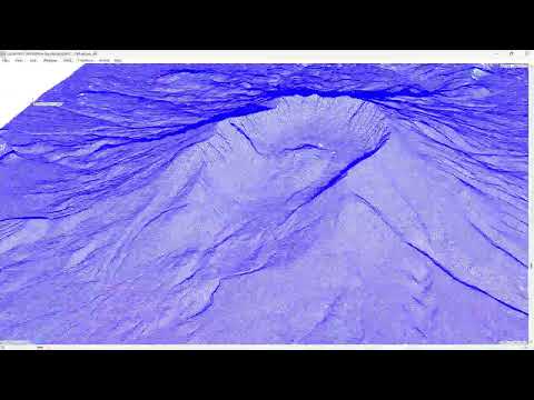
Improved pan/zoom and rotation. Click the image below to watch a video of Mount St. Helens being rotated around an axis in real time.


A 64-Bit Windows installer for the Windows version of QuikGrid 5.4.4 can be found in the release section of this repo.
This repo is for QuikGrid, the Windows-based application originally developed by John Coulthard at https://www.galiander.ca/quikgrid/
This is the full application including the Help File in CHM format for Windows users, not the command-line grid generation app, although it incorporates some of the command-line grid generation code within the Windows app itself. The gridding algorithm, also referred to by some coders as QuikGrid, can be found in various other repos for command-line use and for use within python scripts. The app in this repo is the complete Windows application for contouring, gridding, and 3D mapping. It supports several output formats such as AutoCAD DXF, Surfer grid files, XYZ triplets, ER Mapper files, and VRML. Input formats include DXF data points, ASCII XYZ files, NOAA LAT/LON files, Submetrix SXP files, and DCA files.
Users who wish to create VRML models should note that the latest version of QuikGrid generates VRML version 1.0 and 2.0 files thanks to the work of Volker Enderlein of Coin3D. The default is 1.0 output. To switch to 2.0 file output, go to the Edit menu and select Output Options and place a checkmark in the box for VRML2 output. There is also a VRML Viewer app in the VRML Viewer folder. The viewer is based on the Coin3D library version 4 and is 64-bit, so it will load very large models. I've successfully loaded VRML2.0 files that were in excess of 500MB in size. See the Usage.txt for more info. You can drag and drop a VRML2.0 file onto the executable to load/view it, or use the command line. It also has a GUI. The sourcecode for the viewer can be found at: https://github.com/glls/gl3dv A sample VRML file of Wizard Island is located in the Sample Data folder. Windows 11 also includes a 3D Builder app which will render VRML2.0 files but sometimes fails to render extremely large files. Volker also optimized the VRML output which has significantly reduced the size of VRML files generated by QuikGrid.
If you're using Windows/Visual Studio 2019 or later, double-click the Visual Studio Solution file in the QuikGrid sub-folder and build the EXE.
Native Linux and macOS(arm64) binaries are now available for version 5.7 of QuikGrid. A DMG file is provided under macOS for easy installation and a .deb file for Debian Linux users. The macOS binary is a universal binary and in theory will run on Intel based Macs but this hasn't been tested. Here's a screenshot of the macOS version. Both the v5.7 Linux and macOS versions have feature-parity with the v5.7 Windows version.

Please use the Discussions link at the top of the page for questions or comments and report any bugs using the Issues link and I'll respond as soon as I can.